This book summarizes the outcomes of research results based on field works and recent studies related to soil cover of the dried Aral seabed in Kazakhstan.
The book provides a unique analysis of current air pollution in Germany by correlating results from chemical transport modelling and accumulation monitoring by moss.
For many years, the subject matter encompassed by the title of this book was largely limited to those who were interested in the two most economically important organic materials found buried in the Earth, namely, coal and petroleum.
Although there are numerous publications on the geology of high-grade gneiss terrains, few descriptions exist of how to map and carry out structural analysis in these terrains.
This series of monographs represents continuation on an international basis of the previous series MINERALOGIE UNO PETROGRAPHIE IN EINZELOARSTELLUNGEN, published by Springer-Verlag.
Guided by organic geochemical methodologies, this book conducts a comparative analysis of the characteristics of oil source rocks deposited across various geological eras within typical continental oil-bearing basins, revisits several issues concerning the oil generation theory of continental oil source rocks, and reshapes organic geochemical thinking methods and simulation experimental techniques, challenging the traditionally dominant "e;artificial petroleum"e; theory and experimental techniques.
The main prospects for expanding the mineral resource base of gold are associated with the discovery of typical ore objects within the distribution of productive black shale strata in the Orenburg part of the Southern Urals.
This book provides two state-of-the-art quantitative techniques to determine ultra-trace rare earth elements (REEs) in natural carbonates using solution nebulization-inductively coupled plasma mass spectrometry (SN-ICPMS) and laser ablation-inductively coupled plasma mass spectrometry (LA-ICPMS) with respective applications were presented in this dissertation.
This book is the first systematic treatise of available data and view-points obtained from geological and geochemical studies of the Mo deposits in Qinling Orogen, China.
This volume brings together leading international experts to offer a unique and timely perspective on geomicrobiology through their latest research and findings.
This book details both conventional and advanced geophysical techniques with description of the Electromagnetic (EM) based physics involved in different methodologies of magnetotellurics (MT).
This book details both conventional and advanced geophysical techniques with description of the Electromagnetic (EM) based physics involved in different methodologies of magnetotellurics (MT).
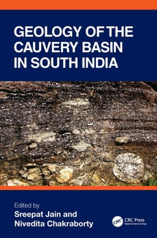
The Cauvery Basin is one of the most widely known and geologically important basins of India, and it has been for decades, and still is, the focus of study for both national and international researchers.
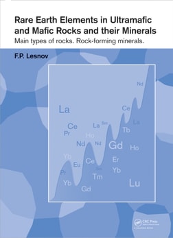
This book gives an overview of the world,s literature on analytical data and theoretical concepts of the regularities of rare earth elements (REE) in ultramafic and mafic rocks of different chemical and mineral compositions , mantle restites (including those composing mantle xenoliths in alkali basaltoids), highly magnesium hypabyssal roc
A thorough revision of the previous "e;Environmental Engineer's Mathematics Handbook,"e; this book offers readers an unusual approach to presenting environmental math concepts, emphasizing the relationship between the principles in natural processes and environmental processes.
Advances in Subsurface Contamination of Porous Media: Indicators, Processes and Modelling provides a high level understanding of the processes concerning common and emergent contaminants through their passage from soil to groundwater.
Modern Statistical Methodology and Software for Analyzing Spatial Point PatternsSpatial Point Patterns: Methodology and Applications with R shows scientific researchers and applied statisticians from a wide range of fields how to analyze their spatial point pattern data.
Structural Analysis of Polymeric Composite Materials, Second Edition introduces the mechanics of composite materials and structures and combines classical lamination theory with macromechanical failure principles for prediction and optimization of composite structural performance.
The congress "e;Arsenic in the Environment"e; offers an international, multi- and interdisciplinary discussion platform for arsenic research aimed at practical solutions of problems with considerable social impact, as well as focusing on cutting edge and breakthrough research in physical, chemical, toxicological, medical and other specific issues on ar
This book reviews the state-of-the-art advances in skew-elliptical distributions and provides many new developments in a single volume, collecting theoretical results and applications previously scattered throughout the literature.
The congress "e;Arsenic in the Environment"e; offers an international, multi- and interdisciplinary discussion platform for arsenic research aimed at short-term solutions of problems with considerable social impact, rather than only focusing on cutting edge and breakthrough research in physical, chemical, toxicological, medical and other specific issue
In spite of the growing importance of Species Sensitivity Distribution models (SSDs) in ecological risk assessments, the conceptual basis, strengths, and weaknesses of using them have not been comprehensively reviewed.
Offers New Insight on Uncertainty ModellingFocused on major research relative to spatial information, Uncertainty Modelling and Quality Control for Spatial Data introduces methods for managing uncertainties-such as data of questionable quality-in geographic information science (GIS) applications.
A clear, comprehensive treatment of the subject, Environmental Statistics with S-PLUS surveys the vast array of statistical methods used to collect and analyze environmental data.
Modeling hydrologic changes and predicting their impact on watersheds is a dominant concern for hydrologists and other water resource professionals, civil and environmental engineers, and urban and regional planners.
Statistical Geoinformatics for Human Environment Interface presents two paradigms for studying both space and interface with regard to human/environment: localization and multiple indicators.
Introduction to Process Geomorphology provides an integrative approach to the process dynamics and the origin of landforms by the contemporary processes involved in their evolution.