Assessment of human casualties in earthquakes has become a topic of vital importance for national and urban authorities responsible for emergency provision, for the development of mitigation strategies and for the development of adequate insurance schemes.
Carbonate sediments are of increasing relevance for archives of past environmental conditions and for economical reasons in areas of geothermal energy and hydrocarbon reservoirs.
ADRIANO DE MAIO IReR President This publication originated from the workshop on "e;Control and risk prevention of dangerous materials and crisis management"e; that took place in Sofia, Bulgaria, in March 2009.
Dendrogeomorphology Beginnings and Futures: A Personal Reminiscence My early forays into dendrogeomorphology occurred long before I even knew what that word meant.
This book tells the story of the Earth itself, explaining the interplay of its gradual geologi- levolution, presented as a generally slow and safe process, with the sudden manifestations of natural hazards, which involve disasters that affect the environment and lead to huge material damage and human losses.
The International Year of Planet Earth (IYPE) was established as a means of raising worldwide public and political awareness of the vast, though frequently under-used, potential the Earth Sciences possess for improving the quality of life of the peoples of the world and safeguarding Earth's rich and diverse environments.
The NATO Advanced Research Workshop, "e;Decision Support for Natural Disasters and Intentional Threats to Water Security"e; was the result of close collaboration between environmental, security, water resource, and health officials in the United States and Croatia.
Based on the suggestions made by the speakers of Plenary Session IV "e;Ch- lenges to the management of water resources and to countering deserti cation in the Mediterranean region"e; during the 15th Economic and Environmental Forum, the OCEEA proposed to organize a workshop on "e;Water Scarcity, Land Degra- tion and Deserti cation in the Mediterranean region - Environment and Security Aspects"e;.
The major challenges of the 21st century faced by human beings are how to achieve water security, food security, energy security and environmental security.
This book is the second in a series that examines how geographic information te- nologies (GIT) are being implemented to improve our understanding of a variety of hazard and disaster situations.
This study provides innovative mathematical models for assessing the eruption probability and associated volcanic hazards, and applies them to the Campi Flegrei caldera in Italy.
Le catastrofi sono classificate in base agli elementi della tradizione filosofica ellenica e la loro ragione fisica è alla base dell'intera trattazione.
This book comprises the main results of the Scenario (Support on Common European Strategy for sustainable natural and induced technological hazards mitigation) project, funded as a Specific Support Action under the VI FP.
In this edited volume on advances in forensic geotechnical engineering, a number of technical contributions by experts and professionals in this area are included.
Plant tissue culture is an essential component of Biotechnology which has gained unbeatable recognition in plant sciences for successful micropropagation and improvement of plant species, leading to the commercial application.
The International Conference on Water, Energy, and Environment for Sustainability (IC-WEES) 2022 is a flagship conference of National University of Sciences and Technology (NUST), Pakistan.
In Time of Emergency: A Citizens Handbook on Nuclear Attack, Natural Disasters provides individuals and families with information on what can and should be done to enhance survival in the event of a natural or man-made disaster.
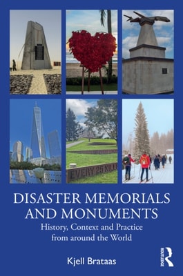
Bringing together the historical and the contemporary, the political and the personal, Disaster Memorials and Monuments: History, Context and Practice from around the World presents a wide-ranging understanding and exploration on memorials and monuments built in the aftermath of accidents, natural disasters and acts of violence.
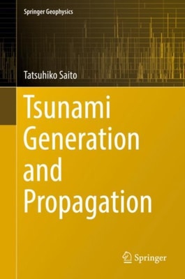
This book introduces a framework of tsunami modelling from generation to propagation, aimed at application to the new observation started in Japan after the devastating tsunami of the 2011 Tohoku-Oki earthquake.
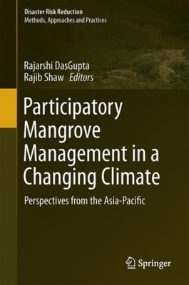
This book outlines the performance and management of mangroves in the changing climatic scenario of the Asia-Pacific region and draws examples and lessons from the national and community-driven mangrove conservation programs of relevant countries including Pakistan, India, Bangladesh, Sri Lanka, Myanmar, Thailand, Cambodia, Indonesia, the Philippines, and Japan as well as the Pacific islands.
This book focuses on the ecological impacts of the Great East Japan Earthquake and resulting tsunamis, a rare and extremely large disturbance event, on various coastal ecosystems in Japan's Tohoku area, including sub-tidal and tidal animal communities, sand dune plant communities and coastal forests.
This book is a collection of papers presented at the International Workshop on Geotechnical Natural Hazards held July 12-15, 2014, in Kitakyushu, Japan.
This volume synthesizes critical environmental challenges of dynamic earth and human environment systems in South Asia emphasizing geographical dimensions.
This book on multiscale seismic tomography, written by one of the leaders in the field, is suitable for undergraduate and graduate students, researchers, and professionals in Earth and planetary sciences who need to broaden their horizons about seismotectonics, volcanism, and interior structure and dynamics of the Earth and Moon.
Education for Sustainable Development (ESD) and Disaster Risk Reduction Education (DRRE) have overlapping areas of concern focusing on strengthening the link to local communities.
Sustainability of rural communities is threatened by a plethora of factors including climate change and disasters which interact in an intricate manner in making rural people vulnerable and poor.
Devastating damage in the Tohoku region of Japan occurred during and after the earthquake off the Pacific coast of Tohoku earthquake on March 11, 2011.